Wird aktualisiert


Re
Nr. 53 in Umsatzstärkste Apps > Wirtschaft
iPhone Screenshots

Beschreibung
iGIS - The world's first and leading iOS GIS.
True GIS functionality is now available on the iPhone! Your iPhone. Your data. Your maps.
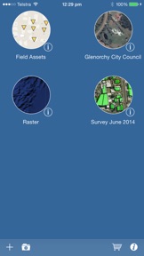
iGIS represents a new era in mobile GIS solutions by enabling users to load, view, investigate, create and export their own data over a background of map service imagery.
Importing data is easy with our unique data import facility using the USB cable or wirelessly on your Mac, PC and Linux. Raster data in many formats (pre-processing required) and ESRI Shapefiles (.shp) are supported at the moment.
Your spatial data is stored on the iPhone, so there’s no need for an Internet connection to see your data – great for field work. We also support over 3000 projections, so no need for re-projection.
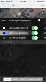
We include support for multiple layers of points, lines, and polygons – all styled as you like. Imagery layers too in V5.
Add comments to your maps - A point layer is added with a name and description field.
Add and edit your own layers, via the map display and customisable data entry forms.
Export your layers to ESRI shapefiles for use back in your enterprise.
Other features include:
- Great speed, using our multi-threaded map renderer.
- Support for large datasets.
- Import and export of ESRI Shapefiles.
- Display current GPS location in your chosen projection ( + compass)
- Zoom to current location
- Zoom to data extent
- Map Pan, zoom in, zoom out
- Changeable drawing styles for a layer: size, color, transparency
- Set the draw order and visibility of map layers
- Set the zoom scale for layers via a simple slider
- Select and interrogate feature attributes via point and click
This application is designed for GIS professionals and an understanding of some basic GIS concepts such as layers, shapefiles, projections etc, would make using iGIS simpler. Please let us know if concepts in iGIS are unclear.
Continued use of GPS running in the background can dramatically decrease battery life.
Neue Funktionen von Version 8.4.1
Fixed mandatory fields in custom forms (glc)
Anbieter
Name
Geometry
Informationen
Entwickler
Kategorien
Version
8.4.1
Größe
89,6 MB
Game Center
Nein
VPP Device Licensing
Ja
Bewertung
Altersfreigabe: 4+
Kompatibilität
iOS 9.0 oder neuer
Geräte
iPhone 11 Pro Max, iPad Air 2 (Cellular), iPad mini Retina (Cellular), iPad Pro (11"), iPad (5. Generation) Wi-Fi, iPad (6. Generation) Wi-Fi, iPod touch (6. Generation), iPad Pro (11") Wi-Fi + Cellular, iPad (6. Generation) Wi-Fi + Cellular, iPad Pro (12,9", 3. Generation), iPad (5. Generation) Wi-Fi + Cellular, iPad mini (5. Generation) Wi-Fi + Cellular, iPad mini (5. Generation), iPad Pro, iPad mini 3, iPad mini 4 (Cellular), iPad mini 4, iPhone 11, iPod touch (7. Generation), iPad mini 3 (Cellular), iPad Air, iPad Air 2, iPad Pro (12,9", 2. Generation), iPad Pro (Cellular), iPad Pro (9,7 Zoll) (Cellular), iPad Pro (10,5") Wi-Fi + Cellular, iPad Pro (9,7 Zoll), iPad mini Retina, iPad Air (Cellular), iPad Air (3. Generation) Wi-Fi + Cellular, iPhone 6 Plus, iPad Air (3. Generation), iPad Pro (10,5"), iPad Pro (12,9", 2. Generation) Wi-Fi + Cellular, iPhone 6, iPhone XR, iPhone XS, iPhone 6s, iPhone SE, iPhone 7 Plus, iPhone 6s Plus, iPhone 5s, iPhone X, iPhone 8, iPhone XS Max, iPhone 8 Plus, iPhone 7, iPhone 5, iPad (7. Generation) Wi-Fi, iPhone 5c, iPad (7. Generation) Wi-Fi + Cellular, iPhone 11 Pro, iPad Pro (12,9", 3. Generation) Wi-Fi + Cellular
Sprachen
Englisch
App Store: Kundenbewertungen
Bewertungen & Rezensionen
0,0 von 5 (Keine Bewertung)
App Store: Kundenrezensionen
Kein Eintrag